Georoute Bad Lausick


- 0:51 h
- 3.37 km
- 20 m
- 20 m
- 159 m
- 179 m
- 20 m
- Start: Bad Lausick station, Bahnhofstr. 2, 04651 Bad Lausick
- Destination: Address: Bahnhofstr. 2 · 04651 Bad Lausick
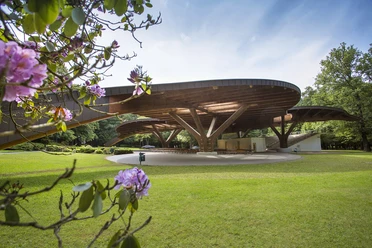
The city tour begins in the spa park of Bad Lausick, which was created around 1840. Besides its variety of plants, the park also houses large and old trees as well as a butterfly-shaped open-air stage, which invites you to concerts or the annual fountain festival in summer. Along the Steingrundbach riverbank, the route continues into the town. Here, the Romanesque pillar basilica St. Kilian can be visited and the spa and city museum offers a glimpse into the town's past.
Bad Lausick’s development from a mining town to a recognized spa town can be explained by its special geological situation. The subsoil consists of former volcanic ash, the Buchheim porphyry tuff, and the Buchheim quartz porphyry. The volcanic porphyry was quarried as building material in nearby quarries. Brown coal, clay, kaolin, and peat could also be extracted in this resource-rich area.
With the opening of the Herrmannsbad in 1821, spa operations began using the now-closed, shallow mineral waters. Since the drilling in 1998, the thermal mineral water for spa operations has been pumped from over 1,300 meters deep.

Good to know
Pavements
- Unknown (89%)Asphalt (11%)
Best to visit
- suitableDepends on weather
Directions
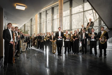
The hike begins at the Sachsenklinik at Badstraße 35 in Bad Lausick. Just behind the "Haus Herrmannsbad," stairs lead down into the spa park. To the right is the home of the Saxon Wind Philharmonic, based in Bad Lausick. The chosen route through the spa park passes the butterfly-shaped covered open-air stage, the Albert Fountain, the Matthes Fountain, and the large duck pond – the central pond system in the spa park.
You leave the spa park straight ahead via Parkstraße, heading into the Steingrund valley, and stay on the path south of the brook.
The beautiful river meadow path flows into Bernbrucher Weg. At this point, turn left, follow Bernbrucher Weg to Käthe-Kollwitz-Straße, then hike along this street in a half-left direction until a narrow path on the left leads towards the cemetery. Take the cemetery path starting on the right to Burgstraße and follow the paths leading to the church portal. Walk back over Kirchgasse to Burgstraße, turn right, and follow Burgstraße, later continuing on Badstraße back to the spa park, the starting point of your hike.
Tour information
Cultural Interesting
Loop Road
Equipment
Sturdy footwear or sports shoes, water and provisions if needed.
Directions & Parking facilities
- Getting there
By car from Leipzig via the A72 and B176 to Bad Lausick.
ParkingOn both sides of Bad Lausick station there is a parking lot with free parking spaces.Public transportationYou can reach Bad Lausick station by train as well as by regional buses of ThüSac. Author
Geopark Porphyrland. Steinreich in Sachsen
Organization
LEIPZIG REGION
License (master data)
Geopark Porphyrland. Steinreich in Sachsen

Author´s Tip / Recommendation of the author
- Also pay attention to the information boards of the "Brown Coal Road" in the spa park of Bad Lausick.
Map
- Bad Lausick city map, available at the spa and tourist information Bad Lausick, Straße der Einheit 17, 04651 Bad Lausick
Nearby


Download GPX file