Georoute Wachtelberg-Mühlbachtal


- 1:02 h
- 3.88 km
- 31 m
- 30 m
- 111 m
- 142 m
- 31 m
- Start: Landgasthof Dehnitz, Am Wachtelberg 9, 04808 Wurzen OT Dehnitz
- Destination: Landgasthof Dehnitz, Am Wachtelberg 9, 04808 Wurzen OT Dehnitz
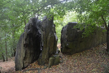
From the parking lot below the Landgasthof Dehnitz, the path leads past a former quarry towards the Mühlbachtal. Here, the pyroxene granite porphyry typical for the location was mined. Along the path, there is a dry stone wall made of the same rock. Upon reaching the valley, the path follows the nature trail "Goldenes Tälchen".
Along the route there are diverse information boards on the fauna and flora of the local Wachtelberg-Mühlbachtal nature reserve. From the valley, the path leads back through the village of Dehnitz into the Mittlere Mulde landscape protection area along the floodplain and Dehnitzer Lache.
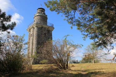
On the way towards the Wachtelberg, the route passes the former Dehnitz windmill and continues through the Wachtelberg-Mühlbachtal nature reserve. Here stands the Bismarck Tower. From March to April, the endangered Pasque flower, threatened with extinction in Saxony, blooms nearby. The view from the tower offers a panoramic view into the former basin of the Wurzen caldera and the nearby quarry, from which the locally typical pyroxene granite porphyry was also mined until the 19th century. The rock provides insights into the volcanic history of the area. From the quarry, the path leads back to the parking lot.

Good to know
Pavements
- Unknown (69%)Asphalt (15%)Gravel (2%)Path (14%)
Best to visit
- suitableDepends on weather
Directions
The Georoute Wachtelberg in Dehnitz starts opposite the Landgasthof Dehnitz, where you can find parking.
Turn left onto Dorfstraße and follow it, then follow the signs for the nature trail "Goldenes Tälchen". The circular route around the former outdoor pool "Goldenes Tälchen" is accompanied by information boards.
Continue straight over Alte Dorfstraße towards the Mulde. At the first junction, turn left towards the playground. After the bridge, follow the street Am Mühlbach on the left and at each possible fork keep right. After the ferry house, the path leads back into the village. On Am Wachtelberg street, go a few meters to the right until on the left side the Osterblumenweg leads up to the Wachtelberg. Please be careful: you are entering an important nature reserve! Please stay strictly on the designated paths. From the plateau, follow the narrow path along the quarry back to Am Wachtelberg street. Turning left, you will reach the starting point after a few meters.
Tour information
Loop Road
Directions & Parking facilities
- ParkingParking available at the village entrance (where there is a noticeable height difference), below the Landgasthof Dehnitz, Am Wachtelberg 9, 04808 Wurzen OT DehnitzPublic transportationWurzen station is easily accessible at a distance of 2 km.
Additional information
- In Dehnitz, you have connections to the Lutherweg Sachsen, the Muldental hiking trail, and the Mulde cycle path.
Author
Geopark Porphyrland. Steinreich in Sachsen
Organization
LEIPZIG REGION
Nearby







Download GPX file